I’ve been Shattered

.

As a good student of wine, I can tell you what shatter, aka coulure is. I can even quote (probably verbatim) the information on it from the CSW Study Guide—here goes!

“A malady known as coulure (“shatter” in English) can cause poor fruit set, with many flowers failing to become fully developed berries.”

Yep. That’s it—and that was about the extent of my knowledge until one night when I suddenly wanted to know more. So, a few textbooks, websites, and phone calls later, here is what I now know about coulure.

For starters, the word is pronounced “coo-LYUR.”

Put simply, coulure occurs when a large number of a vine’s grape blossoms stay closed, or for some other reason they fail to become fertilized. These failed flowers never get the chance to develop into grape berries but rather shrivel and fall off the vine.

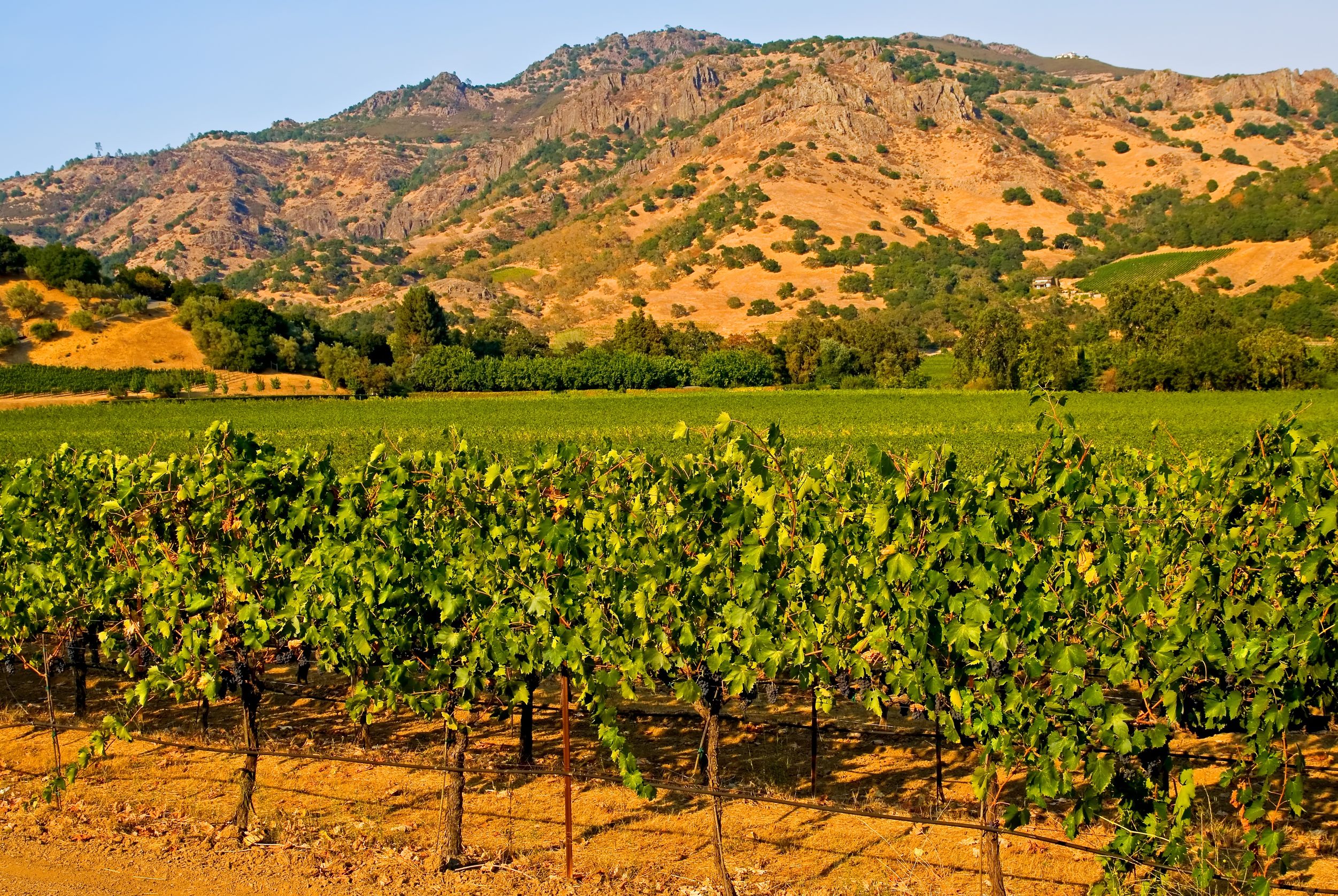
In French, weather-induced coulure is referred to as coulure climatique, and the main culprit behind coulure is indeed the weather.

  • The uncooperative weather—when too cold, rainy, or wet (shatter is a bigger threat in areas with marginal climates)—slows down the plant’s rate of photosynthesis, which leads to carbohydrate deficiencies in the vine. This deficiency causes the vine to conserve its resources, and the energy that would go into ripening flowers and fruit is diverted elsewhere. The blossoms eventually shrivel and drop off, along with the small stems that attached the blossoms to the vine.
  • Excessively high temperatures during flowering and fruit set can cause coulure—again as a result of the shut down of photosynthesis—as the necessary enzymes lose their shape and functionality. In a prolonged heat event, coulure may be caused via excessive shoot-and-leaf growth as well as cellular respiration, either of which can lead to carbohydrate deficiencies.

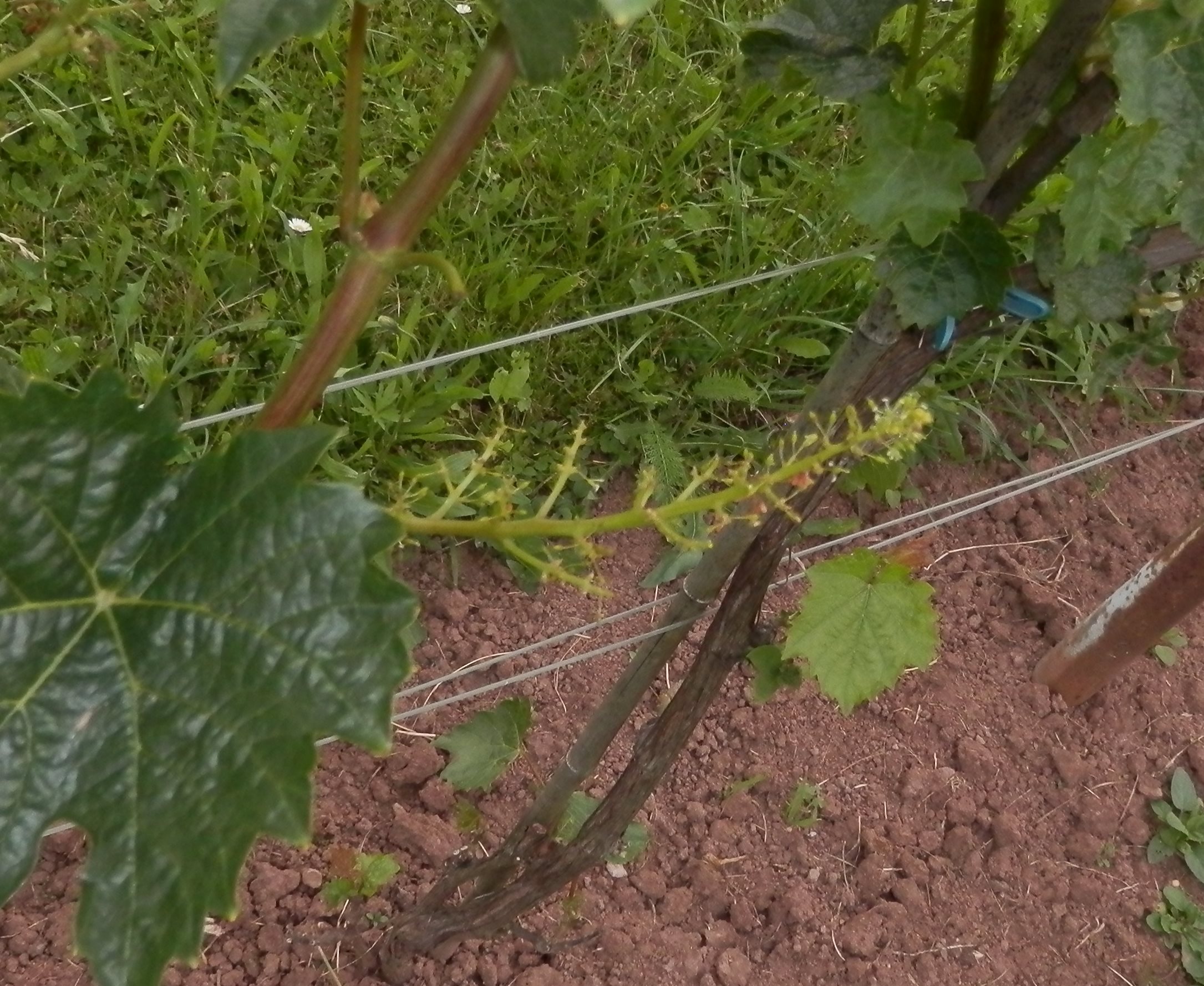
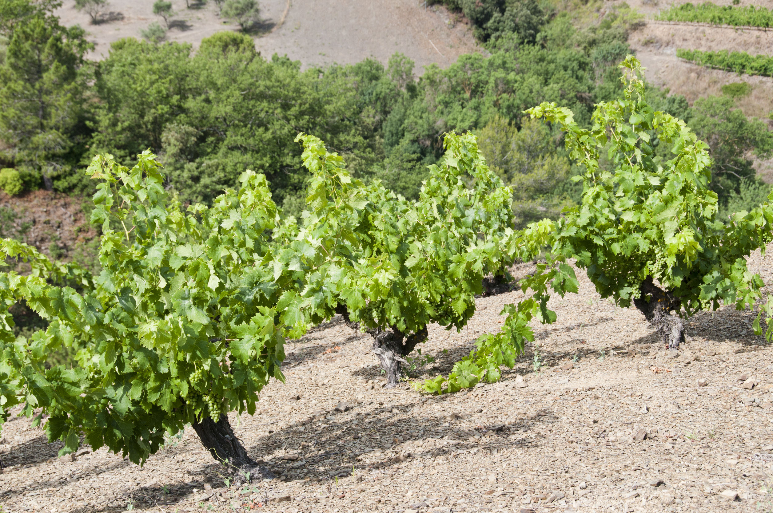
Photo by Hvczech (Public Domain/via Wikimedia Commons)

Besides the weather, coulure can be caused by overly-fertile vineyard soils and excessive use of high-nitrogen fertilizers, both of which can lead to excessively vigorous vine growth that can drain a plant’s carbohydrate reserves. Another possible cause is overly vigorous pruning, which can fail to provide enough potential for the growth of amount of leaf grown necessary for photosynthesis. In addition, certain grapes, such as Grenache, Malbec, Merlot, and Muscat Ottonel are particularly prone to coulure.

Coulure is not always preventable, but some good practices to follow include:

  • Taking care not to over-prune and encouraging the vines to develop enough leaf coverage to provide for adequate photosynthesis.
  • Tip-trimming (snipping the tips of developing shoots) near the end of the flowering period can help prevent carbohydrate deficiencies.
  • In some places, performing winter pruning late in the season may reduce the risk of coulure by delaying bud break which in turn increases the probably for warmer weather at flowering.

Hopefully, all this chitter-chatter has cleared up a bit about shatter (sha ooobie shatter)!

References/for more information:

The Bubbly Professor is “Miss Jane” Nickles of Austin, Texas… missjane@prodigy.net

Five Fast Facts about the Mayacamas Mountains

.

The Mayacamas Mountain Range is a short mountain range—stretching just 52 miles (80 km) in a northwest-southeasterly direction—but it is very well-known to wine lovers as the range that forms the dividing line between Napa and Sonoma counties. However, the famous Napa/Sonoma divide only accounts for about 30 miles of the famous mountains’ total length of 52 miles. Read on to see what else makes the Mayacamas Mountains famous!

#1—Cobb Mountain: Cobb Mountain, peaking at 4,720 feet (1,439 m), is the highest point in the Mayacamas Range. It lies just outside of the town of Cobb in Lake County. The mountain is located outside of the range of any Lake County AVAs, but is only about five miles south of the southern edge of the Red Hills—Lake County AVA (and the larger Clear Lake AVA). This portion of the Mayacamas is responsible for the rolling hills and high-elevation vineyards of the Red Hills-Lake County AVA, which range in elevation from 1,600 to 2,500 feet (490 to 760 m) above sea level.

.

#2—Mount Saint Helena: Mount Saint Helena, located at the boundaries of Napa, Sonoma, and Lake Counties, has five peaks that form something of an “M” shape. One of those peaks is located within the Knights Valley AVA and is the highest point in Sonoma County. The second-tallest peak—at 4,200 feet (1,280 m)—is the highest point in Napa County (this peak is located within the Napa Valley AVA but to the north of the Calistoga AVA). Both of these peaks may be reached via hiking trails located within Robert Louis Stevenson State Park.

#3—The Napa River: Mount Saint Helena is the source of the Napa River. The Napa River runs for 50 miles (88 km) from the southeast slope of Mount Saint Helena through the revered Napa AVAs of Calistoga, St. Helena, Rutherford, Oakville, Yountville, and Oak Knoll (as well as the city of Napa) before heading towards the Napa/Sonoma Marsh. The last 17 miles of the Napa River take it from the Trancas Steet bridge in Napa to the city of Vallejo through the Carquinez Straits—a long estuary bordering and empyting into San Pablo Bay.

.

#4—The Watersheds: Towards their northern edge—just before the Mayacamas Mountains blend into the Mendocino Range in Mendocino County, the Mayacamas Mountains form the boundary between the watershed of the Russian River (as it flows south into Sonoma) and Clear Lake. This is one of the differentiating factors between the terroir of Mendocino County and Lake County.

#5—The Howell Mountains: The famous Howell Mountain AVA (of Napa Valley) is actually located within a mountain range known as the Howell Mountains. The Howell Mountains blend into the Mayacamas in northern Napa just north/west of their famous namesake mountain and namesake AVA. The Howell Mountains begin just north of San Pablo Bay and form the border between the Suisun Valley (of Solano County) AVA and the Napa Valley AVA. From there, they extend to the north/northwest for about 40 miles (64 km), after which they blend into the Mayacamas. The Howell Mountains are also known as the Mt. George Range; the southern portions of the mountains are often referred to as the Napa Hills.

.

In terms of mountainous parentage, the Mayacamas Mountains are considered to be part of the Coast Ranges of California—which (in addition to the Mayacamas Range) include the Vaca Mountains, the Mendocino Range, and the Santa Cruz Mountains. The Coast Ranges of California span for over 400 miles (640 km) from Humboldt County, through Mendocino, onward through Napa and Sonoma—all the way south to Santa Barbara County.

References/for more information:

The Bubbly Professor is “Miss Jane” Nickles of Austin, Texas… missjane@prodigy.net

Wine Geo: Pass, Gap, and Gorge

.

I checked the ever-expanding list of American Viticultural Areas (AVAs) the other day, and for some reason my attention was drawn (once again) to the various geological formations that are mentioned in the titles. These include ridge, slope, plateau, sound, highlands, peak, ledge, and delta.  Fascinating! But…what do they all mean?

Let’s consider these for now: pass, gap, and gorge—as in Pacheco Pass, Templeton Gap, and Columbia Gorge.

What is a pass? Geomorphologically speaking, a pass (often referred to as a mountain pass) is a low-lying, somewhat flat area surrounded by much higher and more rugged terrain. A pass forms when a glacier or stream erodes away between two mountains or a series of mountains. Passes are typically the easiest route for people to travel across mountain ranges and many of the best-known passes in the world—such as the Great St. Bernard Pass in Switzerland and the Khyber Pass between Afghanistan and Pakistan—have served this purpose for millennia.

The Pacheco Pass AVA is located in north/central California, straddling the borders of San Benito and Santa Clara counties.  Casa de Fruta, part of a large fruit orchard and fruit stand complex catering to thirsty tourists on the road to Gilroy and Santa Cruz, is the only winery within the AVA. The area was awarded an AVA in 1984 after a petition was filed by the Zanger family (the owners of Casa de Fruta), who produce fruit wine under the Casa de Fruta label and vinifera-based wines under the Zanger Vineyards label.

Highway 152 along the Pacheco Pass. Photo by Chevy111 via Wikimedia Commons

The Pacheco Pass itself is a 15-mile long corridor that crosses the Diablo Range (part of the California Coast Mountain Ranges) along what is now State Highway 52. The Pass was named for Francisco Perez Pacheco who owned the land in the mid-1800s, back when the area was still a part of Mexico known as Alta California. For a time in the 1880s, the pass was known as Robber’s Pass due to two highwaymen that robbed (and sometimes murdered) travelers along the route. Even today, the stretch of the Highway 152 from Los Banos to Gilroy is quite dangerous, as witnessed by the high number of traffic accidents. There are even rumors that the pass is haunted (best not to pick up any hitch-hikers).

What is a gap? A gap is also a low area between two mountains; however, gaps are smaller than passes, and therefore more rugged and difficult to navigate.  Gaps (sometimes referred to as water gaps) are often created through the twin forces of water erosion and tectonic plate uplift.

A wind gap is a former water gap that no longer has any water due to stream capture (the diversion of a stream from its bed into a neighboring stream). The narrow valleys that remain behind after the stream has diverted allow rain, fog, and other climate features to penetrate beyond the point where the mountains would typically halt their progress.

The Templeton Gap District AVA is one of the 11 sub-appellations of Paso Robles. Surrounding the town on Templeton, it is one of the four sub-appellations hugging the western edge of the Paso Robles AVA and is the coolest of them all. The area benefits from a series of water and wind gaps carved through the California Coast Mountain Ranges by some long-forgotten water ways in addition to the Paso Robles Creek and the Salinas River. These gaps draw cool, moist air from the Pacific Ocean inland towards Paso Robles.

.

What is a gorge? A gorge is deeper than a pass or a gap, and is better described as a narrow valley with steep, rocky walls and an often-tumultuous river running through the bottom. The term comes from the French word gorge, which means throat or neck.

Wine students will easily recognize the name of the Columbia Gorge AVA, which straddles the borders of Washington State and Oregon.  The gorge itself is a deep canyon—up to 4,000 feet deep—of the Columbia River that stretches on for over 80 twisty, turn-y miles following the river as it flows west through the Cascade Mountains.  (The AVA covers about 40 of those 80 miles.) The Columbia Gorge (also technically a “water gap”) is the only water route from the Columbia River Plateau to the Pacific Ocean, and was used in 1806 by the Lewis and Clark Expedition (the first U.S. Army expedition to cross what is now the western portion of the United States) to reach the Pacific Coast.

The Columbia Gorge AVA is known for having a remarkable diversity of specific microclimates within its relatively small boundaries—so much so that the Columbia Gorge Winegrowers invite you to experience their “world of wine in 40 miles.” The soils of the Columbia Gorge AVA include alluvial soils from the river beds, colluvial soils from landslides, and soils from volcanic activity (hello, Mount Hood and Mount Adams). The elevation of the vineyards ranges from just above sea level to 2,000 feet high. The cool, moist air coming from the west turns warmer and drier as it travels inland, even losing an inch of rain a mile from west to east. That’s what we call diversity.

The Columbia Gorge

Geo notes: In addition to pass, gap, and gorge, other terms may be used to describe the breaks in mountain ridges: notch, saddle, and col, for example. These terms are not too sharply defined; overlaps exist, and usage may vary from place to place. No one ever said wine (or geology) was easy!

Geomorphology is the study of the origin and evolution of physical features of the surface of the earth (and other planets if you care to venture forth).

References/for more information:

The Bubbly Professor is “Miss Jane” Nickles of Austin, Texas… missjane@prodigy.net

Rah-Rah Rías!

.

As a wine lover, you must surely have a place in your heart for Rías Baixas, the lovely, Albariño-based white wine from Northern Spain.* Crisp and floral, fruity and refreshing, the wines of Rías Baixas are a white wine lovers dream.

However…do you know what a ría is? The word itself sounds a lot like “río,” so you might just assume that it is a local term for “river.” In which case, you would be just a little bit correct.

A ría is actually a type of estuary. There are several types of estuaries, all of which abide by a definition such as the following:

  • Estuary: A partially-enclosed body of water, located on the coast, formed where one or more streams or rivers flow into the ocean. An estuary contains a body of brackish water (a combination of salt water and fresh water) and has an open connection to the sea.

The Cies Islands

A ría is therefore a type of estuary, also known as a drowned river valley or a coastal plain estuary. Rías were formed at the end of last ice age at places where the level of the sea rose in proportion to the coast, and sea water seeped inland into the river valleys. Rías retain the original shape of the river and are usually quite shallow. Rías typically have very rugged, jagged outlines and often include islands as well.

In the United States, Chesapeake Bay, Delaware Bay, and Galveston Bay are all rías. Well-known rías in other parts of the world include Marlborough Sounds (on the northern tip of New Zealand’s South Island), Sydney Harbor in Australia, and the Fiordo di Furore in Campania, Italy (which is technically a ría despite its name).

The coast of Galicia is lined with rías. Those in the north are referred to as the “Rías Altas” (Upper Rías) and are aligned along the “Coast of Death.” Well, the area is not technically referred to as the Coast of Death, but the Galician “Costa da Morte” is a nickname for the region, so-called for the turbulent nature of the waters that in the past led to many shipwrecks.

Diagram of the Lower Rías by Hidrogalicia_ES, via Wikimedia Commons

The sea around the Rías Baixas, (the “Lower Rías”) is calmer, due in part to the presence of islands. The DO itself in comprised of five discontinuous areas, located close to four rías. These are, from north to south:

  • The Ría de Muros e Noia; formed where the Tambre River meets the sea. This is the smallest of the four rías and the only one not to have an island near the mouth.
  • The Ría de Arousa; formed where the Ulla River meets the sea. This is the largest of the five rías. The Ría de Arousa has two lagoons, as well as a large area of sand dunes known as the Dunas de Corrubedo.
  • The Ría de Pontevedra, located around the delightful, vacation-worthy town of the same name, is located where the Lerez River meets the sea. This ría contains a small inlet known as the Ría de Aldan.  Two small islands, Isla Ons and Isla Onza, are situated at the mouth of the ría. The islands are part of the Parque Nacional Marítimo-Terrestre de las Islas Atlánticas de Galicia.
  • The Ría de Vigo, the southernmost, is formed where the Verdugo River meets the sea. The Cíes islands, located at the mouth of the ría, make the area a safe port, and many beautiful marinas are located here.

*Technically, the white wines of the Rías Baixas DO may be produced using Albariño, Loureira, Treixadura, and Caiña Blanca grapes, along with small amounts of Torrontés or Godello—in various proportions depending on label terminology and the sub-region. The DO is also approved for the production of red wines based on Caiño Tinto, Espadeiro, Loureira Tinta, Mencía, Brancellao or Sousón.

The Rande Bridge over the Ría de Vigo

For the geo-curious: other types of estuaries include the following:

  • Fjords: Fjords are deep, steep-sided estuaries formed by glaciers. As the glaciers advanced, they would deepen and widen the original river valleys; at the end of the ice age as the glaciers retreated, they left behind the fjords. Fjords can reach depths of up to 1,000 feet (300 m). The coast of Norway is well-known for its numerous fjords; fjords also make up portions of Puget Sound (Washington State), Glacier Bay (Alaska), and Milford Sound (New Zealand).
  • Lagoons: Common in tropical areas, lagoons are formed in areas where sediment is deposited at the same rate as the sea level rises to form a body of brackish water separated from the sea by a sand spit or barrier islands. Lagoons are typically quite shallow and parallel to the shoreline, as seen in New Jersey’s Barnegat Bay and Italy’s Venetian Lagoon.
  • Freshwater Estuaries: Freshwater estuaries occur where rivers flow into fresh-water lakes. The Great Lakes, located in the United States and Canada, contain many freshwater estuaries.

Other references/for more information:

The Bubbly Professor is “Miss Jane” Nickles of Austin, Texas… missjane@prodigy.ne

Chasing Chasselas

.

All of the grape varieties in France are chasing Chasselas—or ahead of Chasselas, or running side-by-side with Chasselas.

And you thought Chasselas was just an insignificant little grape that only Switzerland cares about. Think again.

Late last night while I was studying the Bordeaux Wine Guide published by the CIVB (Counseil Interprofessional du Vin de Bordeaux) I saw it right there on page 43: “In France the main families of grapes are defined (by typical time of ripening) according to the usual maturity date of Chasselas (the reference variety).”

I had to read it twice and call four of my wine friends to see if they had ever heard of Chasselas being France’s reference variety. No one had. As such, I did a bit of research.

The quick version is: it’s true.

Back in the 1800s, a French botanist named Victor Pulliat (1827-1896) created a classification of grape varieties—The Pulliat Classification—based on their typical ripening date in relation to the Chasselas Doré grape variety

The Pulliat Classification breaks down as follows:

  • Early-ripening grape varieties:  Ripen from eight to ten days ahead of Chasselas Doré
  • First-period grape varieties: Ripen at about the same time as Chasselas Doré
  • Second-period grape varieties: Ripen from 12 to 15 days after Chasselas Doré
  • Third-period grape varieties: Ripen from 16 to 30 days after Chasselas Doré
  • Late-ripening grapes: Typically ripen more than 31 days after Chasselas Doré

Chasselas grapes on day zero (?)

Victor Pulliat was active in Beaujolais during the early days of the Phylloxera crisis, and traveled extensively throughout Europe testing vines, rootstocks, and grafting techniques. He was an early adopter of using American rootstock for grafting and is recognized as helping to “save the vines” of Beaujolais. These days, his memory is honored with the awarding of the Victor Pullliat Prize, awarded to the “best” example of each of the 10 Beaujolais crus at the annual Fête des Crus.

The Pulliat Classification seems like an interesting bit of history in the world of wine, but as I just learned, it is still used. While it seems hyper-specific, it is not the only classification to reach beyond its original intended use. Just look at the fame of the Winkler Scale (created by Maynard Amerine and A. J. Winkler of UC Davis), used to measure ripening in terms of degree-days or heat summation. While originally designed in 1944 to be used in California, it has since been used in many wine growing regions all over the world.

References/for further information:

The Bubbly Professor is “Miss Jane” Nickles of Austin, Texas… missjane@prodigy.net

WineGeo: Grès des Vosges

.

The wines of Alsace are a white wine lover’s dream…dry, powerful Rieslings, spicy Pinot Gris, and aromatic Gewurztraminer are just a few of the amazing white wines that are produced in Alsace. (Shout out to the Pinot Noir for red wine lovers as well.)

The soils of Alsace are just as diverse; as a matter of fact, according to the website of Wines of Alsace, “The terroir of Alsace is a geologist’s dream…if you walk 100 feet in any direction, you’ll find a different soil composition, making Alsace a complex mosaic unlike any other wine region.”

Soils underlying the vineyards in Alsace range from the schist and granite of the higher elevations (extending into the Vosges Mountains) to the limestone and chalk of the lower slopes, to the clay and gravel of the valley floors. However, it is the unique, reddish-colored sandstone of Alsace—known as grès des Vosges—that inspired this post.

For starters, grès des Vosges (Vosges sandstone) runs in a large, horizontal swath through the Vosges, underneath a granite layer (from which it is derived) and atop a layer of coal. Grès des Vosges is a hard, compact sandstone composed mainly of quartz and feldspar. Its pink-reddish color is due to the presence of decomposing iron (iron oxide, as also seen in red soils such as terra rosa) that occurred as a result of the slow cooling of large masses of magma as it hardened into granite.

The process of the coloring of the sandstone is termed rubefaction. Much of the sandstone in the Vosges is still grey, and some is still undergoing the process of rebefaction (or rebéfaction as they say in French).

The Strasbourg Cathedral, widely considered to be among the finest examples of late Gothic architecture, is partially composed of grès des Vosges, which gives the building its pink-hued appearance. The Strasbourg Cathedral was the tallest building in the world from 1647 to 1874 (227 years). Today, it remains the sixth tallest church in the world and the tallest existing structure built entirely in the Middle Ages.

Carte topographique des Vosges by Boldair, via Wikimedia Commons

Grès des Vosges is considered a unique aspect of the Vosges Mountains and Alsace—so much so that it has earned Protected Geographical Indication status from the EU. It is also still in great demand as a building material, and as such there is also a trade organization, the Union des Producteurs de Grès des Vosges, built around promoting and protecting the stone.

And here I thought it was all about the wine.

References/for more information:

The Bubbly Professor is “Miss Jane” Nickles of Austin, Texas… missjane@prodigy.net

Fuzzy Wuzzy was a Vine

.

.

One of the first things that a serious wine student will learn about Priorat is that it is one of the two DOCa regions in Spain, and that (its red version) is a hearty wine based around the Garnacha Tinta and Mazuelo (Carignan/Cariñena) grape varieties. Next, one might note the list of accessory varieties, which include some well-known international varieties (including Cabernet Franc, Cabernet Sauvignon, Pinot Noir, Syrah, and Tempranillo) as well as a grape known as Garnacha Peluda.

There it is: Garnacha Peluda; otherwise known as Hairy Grenache. The name peluda seems to come from the French pelut and means furry.  How cute is that? The “hairy” part of the name refers to the small white hairs covering the underside of the leaf. Other terms used to describe this hirsutulous (botanical term for slightly hairy) characteristic include downy, wooly, fluffy, fleecy, and fuzzy. But they all mean the same thing: this leaf is hairy.

Garnacha Peluda, a mutation of Garnacha Tinta (aka Grenache Noir), is considered a unique variety and is often referred to as a downy-leafed variant of Grenache—which may make the inquiring mind wonder why a certain grapevine would mutate into such a form. The answer is that growing furry leaves is a biological adaptation. Biological adaptations are changes—structural (either morphological [able to be observed] or anatomical [internal]), physiological, or behavioral—that occur over many generations of plant or animal life in order to make the organism better suited to its environment and to improve its chances of survival.

Garnacha Pelut vineyards in Priorat

Garnacha Peluda vineyards in Priorat

The hairy-leafed variation of Grenache is a result of a morphological adaptation to hot, dry environments such as found in Priorat, as well as the Roussillon and Languedoc areas of southern France. (Note: in southern France, the grape is often called Lledoner [or Lladoner] Pelut.) The fuzzy layer protects the vine from water loss due to transpiration, helps shade the leaves, and reflects sunlight to help keep the plant cool. The hairy-leaf solution is one of several ways plants adapt to hot, dry environments. Others include small leaves, curled-up leaves, wax-coated leaves, woodsy stems, and green stems but no leaves.

Compared to its non-hairy cousin, Garnacha Peluda tends to produce wines that are lower in alcohol, lighter in color, and higher in acidity. The Garnacha Peluda grape is authorized for use in the following wines:

  • Recommended/Principle variety in: Terra Alta DO, Languedoc AOC (as Lledoner Pelut)
  • Accessory grape variety in: Empordà DO, Priorat DOCa, Terrasses du Larzac AOC (as Lledoner Pelut), Côtes du Roussillon and Côtes du Roussillon-Villages AOCs (also as Lledoner Pelut)

Vitis aestivalis varieties and native North American grapes native to the southwest, such as Mustang and Muscadine, are also likely to demonstrate the hairy-leafed adaptation. Many other plants have adopted this downy-leafed adaptation as well, including rosemary, sagebrush, oleander, buckthorn, magnolia, sycamore, potato, petunia, and lamb’s-ear.

Fuzzy-leafed lamb's ears

Fuzzy-leafed lamb’s ears

Another famous hairy-leafed vinifera grape is Pinot Meunier. As meunier means “miller” in French, the grape is so-named for the layer of white, downy hairs on the underside of the leaves, said to resemble grains of flour (as produced by the town miller at the local flour mill). But as we now know, it is all about that morphological plant adaptation.

References/for further information

The Bubbly Professor is “Miss Jane” Nickles of Austin, Texas… missjane@prodigy.net

The pH of it all

.

.

When we talk about wine, we talk about acidity, and when describing wines, one of the typical ways to discuss acidity in wine is to use the pH scale. Dedicated students of wine can easily quote 2.9 to 3.9 as the typical range of pH in wine.

I personally love the zip and zest of highly acidic wines and adore Mosel Riesling (the drier the better), New Zealand Sauvignon Blanc, and even 100% Sicilian Grillo. I’ll take the tongue-curling antics of a wine with a pH of 2.9 any day.

But what exactly is pH? You probably already know that it is a scale runs from 0 to 14 and measures how acidic or basic (alkaline) a substance is. But what does that mean? To answer this question we need to dive into some science…we can start with chemistry and biology, and might just have to visit the physics department (and if we are going there, it better be worth it). So here we go!

About the p and the H: First things first—the term “pH” stands for “power of hydrogen.” The term was invented in 1909 by the Danish biochemist Søren Peter Lauritz Sørensen, so originally the “p” stood for potenz (the German word for power). The “H” (for us absolute beginners) is the element symbol for hydrogen, and the pH scale reflects the concentration and type of the hydrogen-based atoms in a solution. (Note: some references define the “p” in pH as “parts” or “potential.”)

What’s hydrogen got to do with it: Hydrogen is the common element to all acids. What determines whether a solution is acidic or basic is the form and degree of saturation of hydrogen ions.

.

.

Define ions, please: To put it as simply as possible—ions are atoms or molecules that have lost or gained an electron over the course of their travels. In the case of hydrogen, this can occur when water splits apart.  If a hydrogen atom loses an electron, it becomes positively charged and is known as a hydrogen ion (H+). If a hydrogen atom gains an electron, it becomes negatively charged and is known as a hydroxide ion (OH).

Hydrogen ions: An acid is a molecule that can split apart in water and release hydrogen ions (thus, acidic solutions have measurable concentrations of hydrogen atoms). Bases are stronger in hydroxide ions. In neutral solutions, the two are roughly equal and they cancel each other out (neutralize each other).  The way that these hydrogen molecules react in water is the basis for the pH scale.

Deliver me from logarithms: The pH scale is logarithmic. Logarithms are multiples of ten; that means that for every full integer on the pH scale, the strength of the acid or base increases tenfold. Thus a pH of 2 is ten times more acidic than a pH of 3—and a pH of 2 is 100 times more acidic than a pH of 4. If this seems confusing, consider another logarithmic scale, the Richter Scale, where an earthquake measuring 7 is ten times stronger than a 6.

Liquid required: A substance has to be water-based in order to have a pH. Powders and oils (such as vegetable oil or olive oil) cannot be measured on the pH scale. There are, however, several other ways of measuring acidity.

The neutrality zone: A 7 on the pH scale is neither acidic nor basic, and considered neutral. Distilled water is generally neutral, but other types of water are not. An interesting (kind of gross) fact is that  human blood is very close to neutral (just slightly basic) and often has a pH of 7.35 to 7.45. Any deviation from this ideal blood pH can have devastating effects on one’s health.

.

.

Just the basics: In the wine world we deal with levels of acidity, but it is interesting to understand the types of substances on the other end of the scale.  Here are a few common items and their basic pH levels:

  • 8: Baking soda, sea water
  • 9: Toothpaste
  • 10: Milk of Magnesia
  • 11: Ammonia
  • 12: Soapy water
  • 13: Oven cleaner
  • 14: Drain cleaner

The equation for pH: Never mind. If you are interested (and have a logarithmic calculator and know how to use it) click here.

References/for more information:

The Bubbly Professor (who has not formally studied chemistry or physics since college) is “Miss Jane” Nickles of Austin, Texas… missjane@prodigy.net

The (Lucky) French Thirteen

Administrative map of the 13 (new as of 2016) regions of France

Administrative map of the 13 (new as of 2016) regions of France

It’s called territorial reform.

As a citizen of the world, you have no doubt heard by now that in January of this year (2016), after years of debate, the French government reduced the number of the administrative regions in Metropolitan France from 22 to 13. This “simplification” has been dubbed le big bang des régions by the French media.

Despite their original intent (and hopefully, eventual success) such changes tend to complicate things in the short term. In this regard, we wish the French well.

On a more selfish note, as a lifelong student of wine this means I need to re-do some of my flashcards. I’m in the process of doing just that, but for now I felt the need to make a quick survey of how these new administrative regions affect the study of French wines!

First, some quick good news: A lot of wine study deals in departments, and these have not changed. There are still 101 departments in France, which include: 94 on the mainland, 2 in Corsica, and 5 overseas territories (Guadeloupe, Martinique, French Guiana, Réunion, and Mayotte). Your studies of the Haut-Rhin, Gironde, and Lot-et-Garonne have not been in vain.

And for some more good news, the following administrative regions of France have not changed:

  • Bretagne (Brittany)
  • Centre (although the name has changed to Centre-Val de Loire)
  • Île-de-France
  • Pays de la Loire
  • Provence-Alpes-Côte d’Azur
The departments - thankfully, there have been no recent changes

The departments – thankfully, there have been no recent changes

That leaves seven newly-defined regions. Here goes:

Grand Est: The newly-formed Grand Est region comprises the former regions of Alsace, Champagne-Ardenne, and Lorraine. The capital city is Strasbourg. That’s right—the Alsace region (technically) is no more. However, the wine region is still referred to as Alsace, and if you look Alsace up in a (non-wine centric) dictionary or encyclopedia, it will define it along the lines of something like “a historic and cultural area of France.” Main wine areas in the Grand Est region include Champagne (parts of which cross over into the new Hauts-de-France region to the northwest), Alsace, Moselle AOC, and Côtes de Toul AOC.

Bourgogne-Franche Comté: This new region encompasses the former regions of Bourgogne (Burgundy) and Franche Comté. The capital city is Dijon. There is nothing too complicated about this region, it is merely the coupling of two former administrative areas into one, with a hyphenated name. Wine regions affected include Burgundy (even Chablis, Irancy, and Saint-Bris made the cut) and Jura. The vineyards of Beaujolais and the Savoie AOC are now partially in the region of Bourgogne-French Comté and partially in the new region to the south (Auvergne-Rhône-Alpes). The good news: the ideal pairing of white Burgundy and Comté cheese now consists of two sister products from the same region.

Auvergne-Rhône-Alpes: Like Bourgogne-Franche Comté, this newly-formed administrative region seems to be merely a late marriage (complete with hyphenated name) between two longtime neighbors. The capital city is Lyon. The main wine regions within the new region include all of the Northern Rhône Valley (from Côte Rotie in the north to Saint-Péray at the southern tip) and Grignan-les-Adhémar (of the Southern Rhône), parts of Beaujolais, and parts of the Savoie AOC.

Occitanie: This new region is made up of the former regions of Languedoc-Roussillon and Midi-Pyrénées.  The capital city is Toulouse. Just like long, lost Alsace, we will read things like “Languedoc is a former province of France. Its territory is now contained in the modern-day region of Occitanie in the south of France.” (Thank you, Wikipedia.) The Occitanie region contains all of the vineyards areas of Languedoc and Roussillon as well as some of the AOCs of Southwest France, including Cahors, Floc de Gasconge, and Fronton. Note: the terms “Languedoc” and “Roussillon” will still be used to refer to wine regions/appellations.

...

Nouvelle Aquitaine: This new region is comprised of the former regions of Aquitaine, Limousin, and Poitou-Charentes. The capital city is Bordeaux. This new area includes all of the vineyards and AOCs of Bordeaux (thank goodness), all of the Cognac-producing region and most of the Armagnac-producing areas (a portion of which stretches into Occitanie). Nouvelle Aquitaine also includes some AOCs of Southwest France, including Bergerac, Buzet, Côtes de Duras, and Monbazillac.

Normandie (Normandy): This area hasn’t changed too much; it just combines the former regions of Upper Normandy and Lower Normandy. This totally makes sense to me and seems like an actual simplification. The new capital city is Rouen. Wine production is not really a thing here, but the apple brandy (with its three Calvados AOCs) and the Camembert cheese is quite good.

Hauts-de-France: Named for this area’s location at the “top” (haut) of France, this new area comprises the two former regions of Nord-Pas-de-Calais and Picardy. The capital city is Lille. Not much wine production goes on in this northerly spot, aside from the fact that the official boundaries of the Champagne region extend ever-so-slightly into the Hauts-de-France’s Aisne department.

Click here for a pdf of the maps-of-france-used-in-this-post, including a blank map of the “New France.”

References/for more information:

The Bubbly Professor is “Miss Jane” Nickles of Austin, Texas… missjane@prodigy.net

A Little bit about the Lot

The town of Estaing on the Lot River

The town of Estaing on the Lot River

The Lot River has its source in south-central France, in a small mountain range known as the Cévennes. The Cévennes Range is part of, and sits alongside, the eastern edge of the much-larger Massif Central.

The highest mountain in the Cévennes is Mont Lozère, rising to 5,575 feet (1,700 m) above sea level.  It is here, on the side of Mont Lozère, that the Lot River begins its 300-mile (482 km) journey as a “winding blue ribbon” through the departments of Lozère, Aveyron, Cantal, Lot, and Lot-et-Garonne. Along this path, the Lot River flows through the AOC wine regions of Estaing, Entraygues-Le Fel, and Cahors before joining the Garonne for the final trip to the sea.

From its beginning in the Cévennes, the Lot River flows for about 60 miles alongside a plain known as L’Aubrac—named for the small town of Aubrac located on its western side. This high plateau extends almost 1,000 square miles, and was created by a series of volcanic eruptions that occurred over 6 million years ago. The plateau of L’Aubrac is somewhat defined by the Lot River; the Lot River itself forms the southern boundary, while the Truyère River defines the northern border.

On its journey across the Aubrac Plateau, the Lot River flows through the town of Estaing. Estaing is considered to be one of the most picturesque towns in all of France. Estaing is also the recipient of a rather new AOC, awarded in 2011. The wines of the Estaing AOC are red, white, or rosé, and typically dry (although off-dry styles are permitted).

The Valentre Bridge over the Lot River (Cahors)

The Valentre Bridge over the Lot River (Cahors)

The white wines of the Estaing AOC are based on a minimum of 50% Chenin Blanc and a minimum of 10% Mauzac; the remainder may include up to 25% Saint-Côme (a local grape also known as Rousselou). The red and rosé wines are based on Gamay, with Fer (Fer Servadou) required in the reds, and two accessory varieties (chosen from a long list of allowed, obscure varieties) required in the rosés.

The western boundary of the Aubrac Plateau is about ten miles upriver from Estaing, at the town of Entraygues-sur-Truyère.  Entraygues-sur-Truyère was founded where the Truyère River (a right tributary of the Lot) flows into the Lot River as it continues its journey down the eastern foothills of the Massif Central.

From Entraygues-sur-Truyère, the Lot River twists and turns for about 4 more miles before it reaches the town of Le Fel. Between these two towns you will find the terraced vineyards of the obscure yet delightful Entraygues-Le Fel AOC. This is a tiny AOC, consisting of about 50 acres in total.

Red, white, and rosé wines are produced here; they are mostly dry but off-dry styles are allowed as well. The white wines of the Entraygues-Le Fel AOC are based on a minimum of 90% Chenin Blanc; the remaining 10% may comprise either Mauzac or Saint-Côme. The red and rosé wines are blends, based on Fer, Cabernet Franc, and Cabernet Sauvignon, plus small allowed amounts of Mouyssaguès and Négret de Banhars. No single grape may be more than 60% of the blend.

Panoramic view of Cahors, surrounded by the Lot River

Panoramic view of Cahors, surrounded by the Lot River

After leaving the town of Le Fel, the Lot River twists and turns through the hills, limestone plateaus, and valleys for about 70 more miles until it reaches the town of Cahors. Here, the Malbec-dominated vineyards of the Cahors AOC follow the twists and turns of the Lot River for over 25 miles. Cahors is a red wine-only AOC, producing the deep, dark, spicy wines known as the “Black Wine of Cahors.” Cahors AOC is produced using a minimum of 70% Malbec, with Tannat and Merlot allowed for the remainder.

The vineyards of Cahors are planted on two distinct soils; those closest to the river are planted on gravelly slopes, while those farther from the river are planted on the area’s limestone plateaus (known as the Causses). Wines produced using grapes planted on the limestone plateaus are known to be more tannic and austere, while grapes planted closer to the river produce wines that are fruitier and more approachable while young.

After the Lot River leaves the vineyards of Cahors behind, it continues to wind its way for another 60 miles before it reaches the town of Aiguillon. At Aiguillon (a commune of the aptly-named Lot-et-Garonne Department), the Lot River joins the Garonne River for its final journey through the vineyards of Bordeaux, into the Gironde Estuary, and finally out to sea.

Map of the Lot River by Lemen, via Wikimedia Commons

Map of the Lot River by Lemen, via Wikimedia Commons

References/for more information:

The Bubbly Professor is “Miss Jane” Nickles of Austin, Texas… missjane@prodigy.net